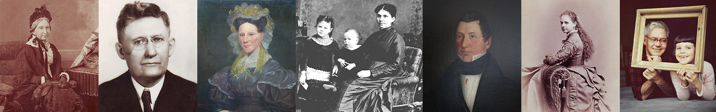
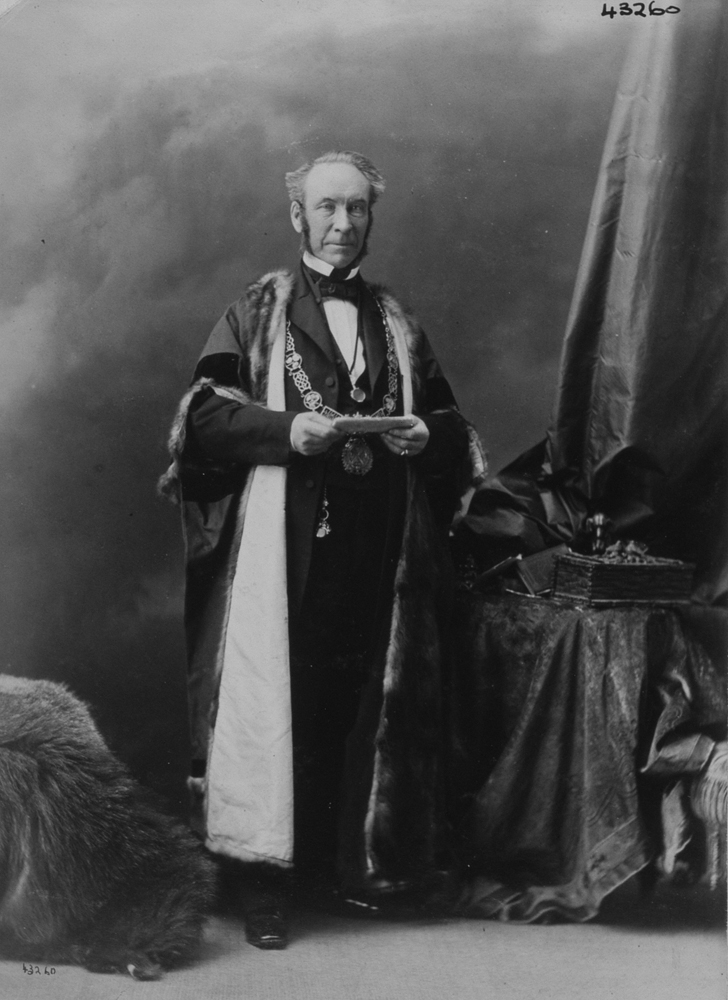
A wealthy Montreal businessman during his lifetime, Thomas Workman (1813-1889) has been largely forgotten, however, several of the companies he helped to found still exist, and his bequest to McGill University supports cutting-edge research today.
Thomas was the eighth of the nine children of Joseph Workman (1759-1848), a teacher turned estate manager, and his wife, Catherine Gowdy (1769-1872). Thomas was probably born at the family home in Ballymacash, a village near Belfast, Ireland (now Northern Ireland). His parents were strict and ambitious for their children and believed that too much hugging would spoil them.
Members of Thomas’s family moved to Canada a few at a time. In 1819, the oldest son, Benjamin, decided to start a new life in North America and booked passage on a ship bound for Quebec. Over the next few years, brothers Alexander and John followed. Fourteen-year-old Thomas, accompanied by Samuel (16) and Francis (12), arrived in Montreal in 1827, following a hazardous voyage across the Atlantic. The brothers lived with Ben and his wife and attended the Union School that Ben owned, studying grammar, mathematics and the classics. Their parents, sister Ann (who was my two-times great-grandmother) and brothers William and Joseph followed in 1829.
In Ireland, the family attended the Non-Subscribing Presbyterian Church of Ireland in Dunmurray, and, like its minister, they strongly believed in freedom of thought in religion. When Thomas first arrived in Montreal, he attended a Presbyterian church, but after his brother Benjamin played a key role in founding a Unitarian congregation in the city in 1842, Thomas became a life-long Unitarian.
Like a number of Irish-born Protestants, Thomas joined the Doric Club, an organization founded in Montreal in 1836 to help maintain Lower Canada’s British connection.1 Along with a number of other Doric Club members, Thomas participated as a loyalist volunteer in the bloody battle of Sainte-Eustache during the Lower Canada Rebellion of 1837-38. The following spring, he was promoted to the rank of first lieutenant.
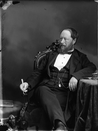
Thomas was described as someone who did not show much emotion, but he did have a life-long close bond with his brother Dr. Joseph Workman, who lived in Toronto. They visited each other and shared interests, such as the new theory of evolution.2 In 1845, Thomas married Scottish-born Anna Eadie (1822-1889). Although they had no children, they moved into a large house at the northwest corner of Sherbrooke and University Street in 1877.
Thomas began his business career working for a Montreal merchant. In 1834, he was hired as a junior clerk at the hardware firm Frothingham and Workman, where his brother William was a partner. Nine years later, Thomas became a partner, and when both William Workman and John Frothingham retired in 1859, Thomas became head of the company. At this time, Frothingham and Workman was the largest hardware wholesaler in Canada, importing tools and supplies from Britain and the U.S. and with its own manufacturing facilities near Montreal’s Lachine Canal.
Like many of his peers, Thomas was involved with several companies over the course of his career. He was a director and later the vice-president of Molson’s Bank, which was incorporated in 1855 and merged with the Bank of Montreal 70 years later. He was a founding director and first president of Sun Mutual Life Insurance Company of Montreal (now simply known as Sun Life) from 1871 until his death 18 years later. He was also involved with the City and District Savings Bank, founded by the Bishop of Montreal and a group of city business leaders to help working people save money. It is now the Laurentian Bank. His other business interests included shipping, insurance and real estate.
A Liberal in politics, Thomas was elected in 1867 to Canada’s first federal parliament, representing the riding of Montreal Center. He did not run in the following two elections, but in 1875 he returned to the House of Commons as the Member of Parliament for Montreal West. The topics he addressed in parliament mainly focused on business interests such as canals, railways and exports and imports.
Governments did not fund health and social services as they do today, so Montreal’s wealthy citizens gave generously to a variety of causes. Thomas donated to the Mackay Institution for Protestant Deaf Mutes (now the Mackay Centre School), and he was president of the Irish Protestant Benevolent Society for two years. He was also a governor of the Fraser Institute and Free Library of Montreal, known in recent years as the Fraser Hickson Library.
Thomas’s wife Anna died in June 1889, and his brother Joseph commented that when Thomas succumbed to diabetes a few months later, he probably died of a broken heart.
Thomas and Anna are buried in the Workman family plot in Mount Royal Cemetery where their massive headstone is inscribed with their names on one side, and the names of his parents and brother Samuel on the other.
Thomas was reputed to be a millionaire – a rare achievement in Canada at the time. The organization that benefited the most from his estate was his neighbour, McGill College, now McGill University. He bequeathed his house to McGill, and it became home to the School of Music. The Otto Maass Chemistry Building is now located on this spot.
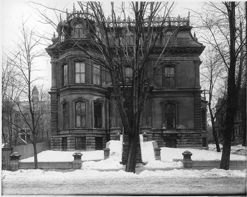
In addition, he left $120,000 to the fledgling department of mechanical engineering, then known as the Applied Science Faculty. Half of that sum paid for the construction of a new building to house machine and technical shops, including a foundry, hydraulics and electrical science.3 The Governor General of Canada laid the building’s cornerstone at a ceremony on Oct. 30, 1890.4 The Workman Wing of the Engineering Building is still there, although it has undergone many changes over the past century and a quarter.5
Thomas also provided long-lasting funds for research. The current Thomas Workman Professor of Mechanical Engineering studies satellites and space robotics, while the current Thomas Workman Emeritus Professor’s expertise is in the interactions between fluids and structures, with applications in the power-generating industry and the aeronautical industry.
This article is also posted on the collaborative blog https://genealogyensemble.com.
Photos credits:
Thomas Workman, Montreal, QC, 1869. William Notman, I-36832, McCord Stewart Museum
Thomas Workman’s House, Sherbrooke Street, Montreal, Quebec, 1912-13. Wm. Notman & Son, VIEW-12850, McCord Stewart Museum
Smith’s Shop in the Workman Building, McGill University, Montreal, about 1901. Photographer unknown. MP-000025286, McCord Stewart Museum
Sources:
1. Gerald J. J. Tulchinsky, “WORKMAN, THOMAS,” in Dictionary of Canadian Biography, vol. 11, University of Toronto/Université Laval, 2003–, accessed May 4, 2026, https://www.biographi.ca/en/bio/workman_thomas_11E.html.
2. Christine I. M. Johnston, The Father of Canadian Psychiatry: Joseph Workman, Victoria: The Ogden Press, 2000, p. 94.
3. MacDonald Engineering, the Workman Wing and the Electrical Wing. https://cac.mcgill.ca/campus/buildings/Macdonald_Engineering.html, accessed May 4, 2026.
4. Keen Science’s New Home. Laying the Corner Stone of McGill’s Latest Buildings, The Gazette, Oct. 31, 1890, p. 2. www.newspapers.com accessed March 10, 2026.
5. McGill. Civil Engineering. History of the Department, https://www.mcgill.ca/civil/about-us/history, accessed May 4, 2026.