Tag: maps

Where did your ancestors live in Montreal?

I am often curious to find out where my ancestors lived at different times of their lives. For most of my 19th and 20th-century Montreal ancestors, this has been relatively easy using online maps and city directories, and I have used the same techniques to find ancestors in Philadelphia, Winnipeg, and other cities. Once I locate them, it is fun to look at the same addresses today using Google Street View. 

In Montreal, the main directory has been published by Lovells since 1842, and these resources are searchable online on the Bibliothèque et Archives nationales du Québec (BAnQ) website. While the directories themselves are in English, this post should help you navigate that French-language provincial archives site.  Go to http://bibnum2.banq.qc.ca/bna/lovell/index.html and, on the left, click on explore.

Then click on Montreal et sa banlieue (Montreal and its suburbs), then on serie principale (1842-1977) and choose the year you want to explore. You can search for either the name of the household head or for the street address. This directory often includes the occupation and/or employer of the household head.

A sample map of Montreal showing a corner of my ancestor’s property on the BAnQ site.

Once you find your ancestor’s home address you can try to find it on a map of the city during the same time period. The page http://services.banq.qc.ca/sdx/cep/accueil.xsp will take you to the BAnQ’s collection of digitized cartes et plans, or maps and diagrams. You can search by lieu (place), by region of Quebec or Canada, or by title of the map, date, author or subject. 

If you are looking for the easiest maps of Montreal to understand, go to the left hand side of that opening page and click on the bottom choice of Collections, Pour en savoir plus, “Sur les cartes de Montreal utiles à la recherché” (to learn more about easy-to-use maps of Montreal).

This will take you to a list of useful maps of the city, such as Goad’s maps, which were created for insurance purposes and identify property owners. 

Searching for property ownership documents is a whole other complicated story I’m not going to talk about here, except to say that these documents can be found — with a lot of effort. Go to https://www.mern.gouv.qc.ca/english/land/register/index.jsp, a site of the provincial department of Énergie et Ressources naturelles Québec, and follow the links to the Land Register of Quebec site.

First, though, you need to know the ward of the city your ancestors lived in, and the cadastral number of the property they owned, which is not the same thing as the street address. You may have to compare different maps of the same area over different time periods to nail this down, remembering that street names and numbers sometimes changed.

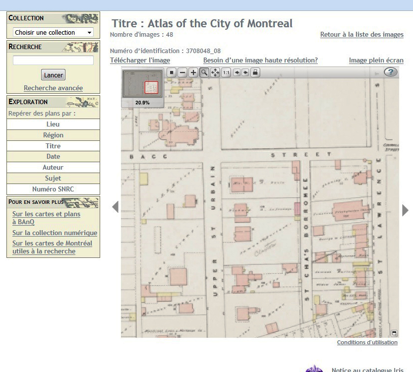
Once you have a firm idea of your ancestor’s geographic location, the 1874 map titled Cadastral plans, City of Montreal (http://services.banq.qc.ca/sdx/cep/document.xsp?id=0000337579) can help you to identify the cadastral number. Once you see the image of the map you want, you can click above it on the left to download it (télécharger l’image) or on the right for a full-screen view (image plein écran). Move the red rectangle in the small map at the upper right to navigate your way around the screen. 

Good luck and have fun!

(This article has also been posted on the collaborative blog https://genealogyensemble.com.)

Maps in Art and Genealogy

 My passion for genealogy, my interest in maps and the enjoyment I get from painting and drawing become even more fun when they intersect with each other.

I have been taking art classes for many years, and my ancestors sometimes turn up in my paintings in some manner or other. Maps are another frequent theme in my artwork, sometimes just as a layer that I cover with paint, sometimes as an image of a place or a route from one place to another. Sometimes I use street grids or contour lines as the starting-point for a drawing, and a birds-eye view of landforms can inspire me to create an abstract image.  

A few years ago, I collected images that were associated with my great-great grandmother Catharine Mitcheson Bagg and put them together in a collage. I included a photograph of a portrait of her; a hand-painted photograph of Fairmount Villa, the house where she lived in Montreal, a letter she wrote and a painting she did on the outskirts of Philadelphia, where she grew up. I glued all these elements on top of some maps of the area where she lived in Montreal. I found these maps on the website of the Bibliothèque et Archives nationales du Québec, I enlarged and printed several sections, coloured them and then covered them with thin rice paper.

 I love old maps, not only because they can be beautiful. Some show places that no longer exist, or that have been swallowed up by urban centers. They can show political boundaries that have changed over time, land use patterns, railway lines that have disappeared, and the locations of church buildings that are now used for entirely different purposes. That makes them an essential research tool for tracking family history.

Family records said my great-great-grandmother Janet MacFarlane was born in Dunkeld, Scotland, and a handwritten note suggested she was born in Craig O’Gowrie, Perthshire. Other notes said Janet’s father was a stonemason before the family left for Canada in 1833, and the family lived near the Tay River.

These were all important clues, but it turned out they were not entirely accurate. Parish records showed that Janet was baptized in Clunie Parish, Perthshire, which is near the Tay and not far from Dunkeld. Frustratingly, I could not find a place called Craig O’Gowrie anywhere.

I searched a number of old maps on the National Library of Scotland’s website and discovered several hamlets called Gourdie in Clunie Parish, including Craigend of Gourdie. When one map showed there had been quarries nearby, I concluded the family had probably lived there. 

I recently participated in a workshop on art and cartography. Our instructor sent us to the park across the street to map, not what we saw, but what we heard: birds, cars, people walking by, someone raking, a loud machine that didn’t stop. That workshop has inspired me to broaden my thinking about the ways maps can represent reality and social history, and to find new ways to make maps into art.

Image sources:

Collage by Janice Hamilton. “Catharine Mitcheson Bagg,” 1865, by William Sawyer, National Gallery of Canada (no. 26744).

Knox, James. “Map of the Basin of the Tay, including the Greater Part of Perth Shire, Strathmore and the Braes of Angus or Forfar.” Edinburgh: W. & A. K. Johnston, 1850. N. pag. National Library of Scotland. Web. 19 May 2015.